The National Archives has announced a project to digitise the National Farm Survey, taken in 1941, thanks to a £2.13 million grant from the Lund Trust.
The survey includes details of over 300,000 farms in England and Wales including how the land was used, location, condition and management as well as details of owners and tenants.
As one of the most requested documents at The National Archives, the digitisation of the 1941 National Farm Survey will help to preserve the original documents as well as improve access for local and family historians researching agricultural labourers and farms.
The first records to be digitised will be the individual farm records (MAF 32) with the accompanying survey maps (MAF 73) coming later.
The project is planned to be completed by March 2027, with the first digital records coming online from March 2026. The resulting database will be freely available online, enabling researchers to discover more about family farms or their local area.
Jeff James, CEO & Keeper of The National Archives said: “This is a unique opportunity to realise the potential of what was seen as a ‘Second Domesday Book’, a ‘permanent and comprehensive record of the conditions on the farms of England and Wales’. Thanks to this partnership, the National Farm Survey, an enormous database of land ownership and land usage in mid-20th century Britain, will be freely available online to researchers in the UK and globally.”
The background to the 1941 National Farm Survey
Before the Second World War, Britain imported about 55 million tons of food a year from other countries. From the start of the war in September 1939, imports of food and fertilisers to Britain all but stopped and the need to increase home production was urgent, along with the implementation of rationing.
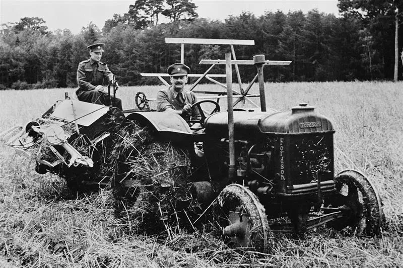
The Ministry of Agriculture and Fisheries set up County War Agricultural Executive Committees with the remit to increase food production. Between June 1940 and early 1941, about 85 per cent of all agricultural land was surveyed. Farms were classified according to their productive state and, where necessary, land was taken into the control of the Committees who organised labour accordingly. A ‘ploughing-up’ campaign was initiated, and large areas of grassland were prepared for cultivation. Help was brought in from the Army and also the Women's Land Army.
The completion of the 1941 National Farm Survey
Once this short-term objective of increasing food production had been more or less completed, a longer-term strategy was required. In April 1941, the Ministry instructed the County War Agricultural Executive Committees to carry out a more comprehensive survey of all farms and holdings of five acres and more, including those of market gardeners, horticulturists and poultry keepers. The survey was begun in the spring of 1941 and was largely completed by the end of 1943.
District Committees, comprised mainly of experienced, practical farmers, visited some 300,000 farms and other holdings, interviewing the farmers and inspecting their properties.
Is there a 1941 National Farm Survey for Scotland?
A similar but more limited survey was also carried out in Scotland between 1941 and 1943: the records of Scottish Agricultural Executive Committees are held in the National Records of Scotland in Edinburgh.
Individual Farm Records (MAF 32)
The individual farm records are made up of four forms. The first three were returns of the 4 June 1941, which were completed by the farmer. On the first, details of agricultural land were given (crops and grass, livestock, horses and labour); the second gave details of any fruit, vegetables for human consumption, flowers or crops under glass and also stocks of hay and straw; and the third form detailed labour, rent and length of occupancy.
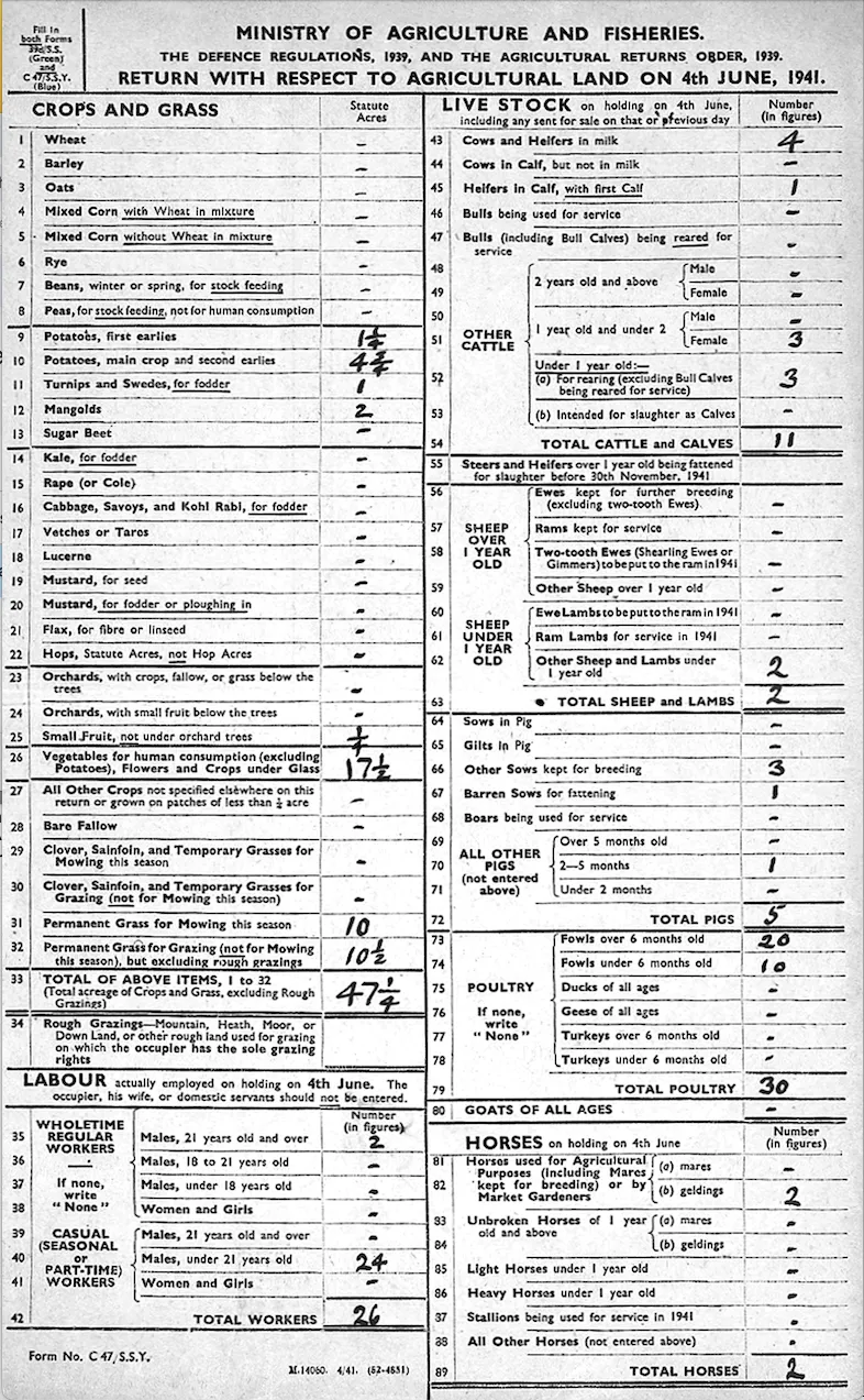
The last form, the Farm Survey itself, is the most important and informative and it was this that was completed by inspection and interview. It also includes the date the survey was carried out.
The most contentious part of the survey, and for which it has some notoriety, was Section D, ‘Management’. Here the inspector had to classify the farm as ‘A’, ‘B’, or ‘C’; and if it was B or C and due to ‘personal failings’ he also had to add further information. The classification referred to the way the farmer managed his resources rather than any inherent problem with the farm itself. ‘A’ was well managed, ‘B’ fairly and ‘C’ badly. Of the 300,000 farms and holdings classified by the Survey, 58 per cent were ‘A’, 37 per cent ‘B’, and five per cent ‘C’.
Survey maps (MAF 73)
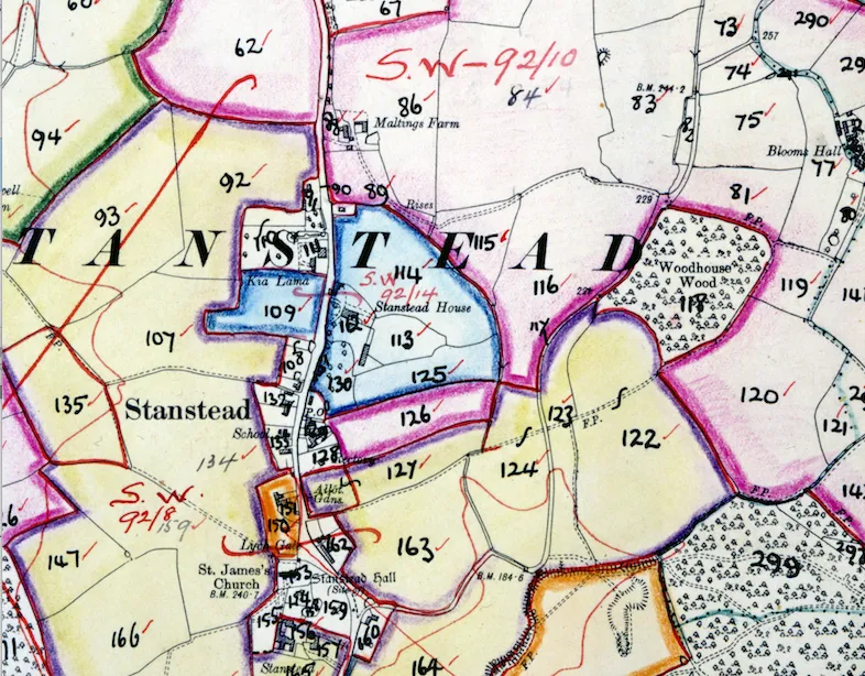
Maps were also produced as part of the survey. If all trace of the farm has now completely disappeared, the area having been urbanised in recent years, these maps could be the only way of discovering exactly where the farm owned by your family was located. The maps can also be used by local and house historians to explore the rural history of more recently ubanised areas.